Thursday, December 6, 2012

The Future


Andean Region, Colombia

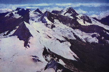
The Andean Region made up of Cordillera Occidental, Cordillera Central, and Cordillera Oriental. 

Creation of the Andean Region landscape:

The Cordillera Occidental, Cordillera Central, and Cordillera Oriental comprise the Andean region in Colombia and were formed through the convergent (subduction) process. The area originated in the Paleozoic ear when the Nazca tectonic plate collapsed with the South American plate. The Cordilleras are a product of different formation processes and are shaped through the river valleys that divide the peaks from one another. The Andes in Colombia will continue to experience orogenic events because the Nazca Plate, moving at 3.7cm/ year, is still sliding beneath the South American Plate. The subduction is also producing minor to major earthquakes and volcanic activity. 

The Cordilleras were formed through the subduction process of the Nazca tectonic plate moving underneath the South American plate. The three mountains are divided by the Cauca River Valley and the Magdalena River Valley.

This shows the process of subduction where the Nazca plate is moving underneath the South American plate. The friction of the plates causes the Andes to grow and also produces volcanoes such as the Galera volcano.

The Andean Region in 1,000 years:

In 1,000 years the Nazca plate will have moved 37 meters under the South American plate, which will move the three Cordillera Mountain ranges to the east. One thing to remember is that the Galeras, a stratovolcano, in addition to many other volcanoes, is on the fault line. Plate movements can possible cause eruption, which can cause not only biotic destruction, but a climate change as well.  Multiple volcanic eruptions will cause cooler temperatures in Colombia. This particular type of volcano can inject large amounts of particulate, of which includes sulfur dioxide and carbon dioxide gas where it combines with water in the stratosphere to form sulfuric acid. Solar radiation cannot penetrate aerosols and volcanic particulate in the atmosphere, lowering Earth’s temperature. In addition to volcanic activity, plate movement will cause multiple earthquakes, which will be deeper and longer because of continual plate collision.

With the increased amount of plate movements, there will be not only multiple volcanic eruptions but also the formation of mountains.

The Andean Region in 10,000 years:

Assuming the Nazca plate keeps moving at the current rate, by 10,000 years it would already have moved a total of 370m into the South American plate. This subduction zone will continue to push the Cordilleras east, while creating volcanoes and earthquakes and another mountain range. Similarly, with the increasing volcanism that causes decreases in regional and global temperatures, Colombia’s climate may change from a fluvial landscape to a glacial and temperate landscape. The cooling temperatures will activate alpine glaciation in the Cordilleras (south of Colombia) while northern Colombia will have a cooler climate. The area will experience massive landslides as volcanic eruptions heat the glaciers and cause major lahar/debris flow. 

This shows that we are currently in a glacial age where the world's climate is cooler than usual. This is likely to occur in Colombia because of the many volcanic eruptions due to the movement of the plates. 
The Andean Region in 1,000,000 years: 

In 1 million years, assuming the Earth is in a glacial age as result of violent volcanism,  the Andean region will look different than today. The Nazca Plate would have already moved 37 kilometers under the South American plate, wedging the Galapagos Archipelago into the Colombian coast. The two river valleys between the Cordilleras will have most likely turned to ice and there will be a col landform where the ice from the mountain range fell.  The rest of the landscape will be carved out by the glacier plucking and carving, resulting in u-shaped valleys.
 
Conclusion:
The Andean region in Colombia will change over the next thousand, ten thousand, and one million years. Different geographical processes will cause the formation of mountains, as well as an increase in volcanism, earthquakes, and erosion.


References:
http://www.infoplease.com/ipa/A0107419.html
http://whatonearth.olehnielsen.dk/nazca.asp
http://earthquake.usgs.gov/earthquakes/eqarchives/poster/regions/nazca.php
http://clasfaculty.ucdenver.edu/callen/1202/Battle/Build/PlateTectonics/PlateTectonics.html
http://clasfaculty.ucdenver.edu/callen/1202/Battle/Build/VolcanicIn/Intrusive.html
https://www.google.com/search?q=colombia+geography&oe=utf-8&aq=t&rls=org.mozilla:en-US:official&client=firefox-a&um=1&ie=UTF-8&hl=en&tbm=isch&source=og&sa=N&tab=wi&ei=OSLBUPi1CMLY2gX9xYHoBA&biw=1280&bih=917&sei=OiLBUOb3MYe72QX0lIDoDA
http://www.google.com/imgres?um=1&hl=en&client=firefox-a&tbo=d&rls=org.mozilla:en-US:official&biw=1280&bih=917&tbm=isch&tbnid=E0k3lLfV6tJ42M:&imgrefurl=http://eyesoncolombia.wordpress.com/2009/09/05/how-the-andes/&docid=39QmelhtFAq0yM&imgurl=http://upload.wikimedia.org/wikipedia/commons/3/3b/Colombia_Topography.png&w=1839&h=2399&ei=oyLBUInxNsL62gWEpIG4Cg&zoom=1&iact=rc&dur=430&sig=111286461184354537651&page=1&tbnh=151&tbnw=116&start=0&ndsp=34&ved=1t:429,r:0,s:0,i:84&tx=96&ty=57

Monday, November 12, 2012

Climate and Weather

Colombia's seasons are classified by rainfall than by temperature changes. The temperature changes range from very hot at sea level to relatively cold at higher elevations but vary little with the seasons, which is partly due to the fact that Colombia is so close to the equator.

 About 86 percent of the country's total area lies in the hot zone. Included in the hot zone and interrupting the temperate area of the Andean highlands are the long and narrow extension of the Magdalena Valley and a small extension in the Cauca Valley; there are alternating dry and wet seasons corresponding to summer and winter, respectively.

Andean highlands

The temperate zone covers about 8 percent of the country. This zone includes the lower slopes of the Cordillera Oriental and the Cordillera Central. In the higher elevations of this zone, farmers benefit from two wet and two dry seasons each year; January through March and July through September are the dry seasons. 

Cordillera Oriental

The cold or cool zone constitutes about 6 percent of the total area, including some of the most densely populated plateaus and terraces of the Colombian Andes; this zone supports about one fourth of the country's total population. The mean temperature ranges between 10°C and 19°C, and the wet seasons occur in April and May and from September to December.

Colombian Andes


Precipitation is moderate to heavy in most parts of the country; the heavier rainfall occurs in the low-lying hot zone.
 
Colombia has a Class A tropical/ equatorial climate based on the classification system where the climate is good for growing crops that demand lots of water and heat such as rice, bananas, and sugar cane. Colombia in particular has  an 'Af' climate where there is no dry season and where there is at least 60mm of rainfall in the driest month.


http://clasfaculty.ucdenver.edu/callen/1202/Climate/EarthTempClim/EarthTempClim.html
http://www4.uwsp.edu/geo/faculty/ritter/geog101/textbook/climate_systems/elements_of_climate.html

Wednesday, October 10, 2012

Weathering, Mass Wasting, Hydrology Basics, and Soils


The gullies below show how water erodes soil. Soil erosion is a natural part of the recycling aspect of the Earth. Every time it rains, raindrops hit the soil with a force which removes soil particles off the surface, then water across the surface carries away the dislodged particles which is called sheet erosion. After flowing as a thin sheet for a short distance, the water forms tiny streams called rills. As more water enters the rills, they erode the soil further, creating trenches known as gullies (shown below). Although most dislodged soil particles do not move far during each rainfall, large quantities eventually make their way down slope to a stream. The stream transports these soil particles, which are now called sediment, and eventually deposits them.


http://www.google.com/url?sa=t&rct=j&q=&esrc=s&source=web&cd=6&ved=0CEkQFjAF&url=http%3A%2F%2Fwww.jkaser.com%2Fresources%2FGeology%2FBook_chapters%2FChapter%25205%2520Weathering%2520and%2520Mass%2520Movement.doc&ei=laV1ULHILeS8igLrxIGwAg&usg=AFQjCNEv9ksfU2oxfIhFSrjlAQIgP1uyPQ&sig2=N_RztzznNe8BkT4ds-7ZgA


The Tatacoa Desert in Colombia can be a prime example of soil desiccation. Soil desiccation is when there is a piece of land which got wet from precipitation or a natural resource and then the water in the soil was evaporated so much, creating cracks in the soil.


Colombia contains a drainage basin, Magdalena which includes its major tributary, the Cauca which covers nearly one-fourth of the surface of the country. The Cauca originates in the Andean Paramo de Las Papas. The drainage pattern of the Magdalena is of a dendritic drainage pattern because the Cauce River flows in between mountains and various surfaces that are "higher". The Cauca River, which contributes a substantial part of its total flow, rises in the mountains south of Popayán and, after passing through the floor of the Cauca valley near Cali, occupies deep canyons in most of its passage through the departments of Caldas and Antioquia before emerging onto the floodplain of the lower Magdalena.


Wednesday, September 19, 2012

Building Earth’s Landscapes


Colombia is formed be two territorial zones, one submerged in the Pacific Ocean and Caribbean Sea and the second, is emerged land which is formed by the Andes Mountain Range.

Sierra Nevada de Santa Marta
The Sierra Nevada de Santa Marta is an isolated mountain range apart from the Andes mountain chain that runs through North Eastern Colombia. It is between two national parks (the Parque Nacional Sierra Nevada de Santa Marta and Tayrona National Park). The mountain range is also a prime example of convergence. Convergence of tectonic plates means that two plates overlap and cause mountains and hills. In this case, the two plates that overlapped are the North and South American plates (http://www.agu.org/journals/tc/tc1104/2010TC002835/2010TC002835.pdf). 

Sierra Nevada de Santa Marta (http://pubs.usgs.gov/pp/p1386i/colombia/marta.html)

Andean region
The Andean region formed when the Nazca plate, and part of the Antarctic plate, collapsed with the South American plate pushing it under the Caribbean plate which created volcanic islands off the Pacific coast of Colombia and the Isthmus of Panama.(http://www.windows2universe.org/geography/andes.html)

Nazca Plate surrounded by other tectonic plates, USGS
Formation of Andes (http://www.kids-fun-science.com/nazca-plate.html)


Andes Mountains (http://www.google.com/imgres)
Volcanoes and Colombia
Colombia has a total of 17 volcanoes, 15 which are still active. The volcanoes are a part of the northern Andes and lie at the junction of 3 tectonic plates: Nazca, Carribean, and South American plates.

Map of Colombia's major volcanoes (USGS)
Major volcanoes in Colombia (http://www.volcanodiscovery.com/colombia.html)

Galeras Volcano, Colombia
The Galeras volcano is the most active volcano in South America and has been erupting for more than a million years. It is a stratovolcano, which is a tall, conical volcano built up of many layers (strata) of hardened lava, tephra, pumice, and volcanic ash. It is located in the Columbian segment of the Andes Mountains. (http://www.volcanodiscovery.com/colombia.html) The volcano was formed
Galeras Volcano is formed along Nazca and South American plates. It is a convergent boundary and is oceanic-continental. 

Galeras Volcano- radar image (http://volcano.oregonstate.edu/oldroot/volcanoes/galeras/galeras.html)
Galeras Volcano (http://volcano-club.blogspot.com/2011/11/decade-volcanoes-part-one-with-added.html)


Saturday, August 25, 2012

Introduction.

Hey guys,

My name is Victoriya Shleyfer and I am a second year student at the University of Colorado at Denver. I am originally from Russia but have lived here pretty much my whole life and have gone to school in Colorado. I am a double major in Accounting and Finance and am in the Business School here at the University.

Tayrona National Park, Caribbean Coast, Columbia


I picked Colombia to be my place of interest to explore because I have always been fascinated by the culture, language, and the people so now it is time to take a scientific view of it and see what that has to hold. Also, I’m interested in Colombia because it has a little bit of everything. It borders the Pacific Ocean so that means beaches. The country also has a fascinating city and mountains so it’s a little taste of everything. The last reason why I chose Colombia is because I would really love to visit the country one day and hopefully see the beautiful geographical sites that I have seen in pictures. 

Thank you for joining me.